 Historical records show that one of the most effective solutions to flooding problems today is the Grand Canal in China, which is approximately 1,795 kilometers long and was constructed over 2000 years ago.
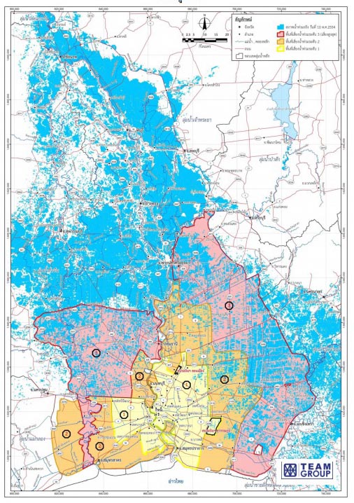
Based on statistics showing the highest water volume recorded in 2006 in Nakhon Sawan province, approximately 6,000 cubic meters per second, the amount of water that can be drained out in Bangkok is measured at about 4,000 cubic meters per second. Therefore, the remaining 2,000 cubic meters per second of water, exceeding the capacity of the Chao Phraya River in Bangkok, must be distributed to flood areas on both sides of the Chao Phraya River before reaching Bangkok.
A concrete solution, involving an eastern and western canal system capable of draining water into the sea at a rate of approximately 2,000 to 3,000 cubic meters per second, would effectively solve the flooding problem comprehensively.
Details of the Eastern Canal.
The canal project begins at the Yom River, with a weir constructed at a height of approximately 140 meters (MSL). A large diversion canal is then constructed, lowering the water level from Long District, Phrae Province, through Wang Chin District, Phrae Province, and Si Satchanalai District, Sukhothai Province, to the Nan River at Mueang District, Uttaradit Province, at a level of approximately 130 meters (MSL). From the Nan River, a diversion canal is dug from the 130-meter (MSL) level, passing through Tron and Pichai Districts, Uttaradit Province, and then through Phrom Phiram, Wat Bot, Mueang, Wang Thong, and Nen Maprang Districts, Phitsanulok Province.
The waterway flows from Phetchabun Province, through Nong Bua District in Nakhon Sawan Province, through Bueng Sam Phan District in Phetchabun Province, into the Pa Sak River at Nong Phai District in Phetchabun Province. A weir is constructed on the Pa Sak River at approximately 100 meters (MSL). From there, a diversion canal is dug from the Pa Sak River at 100 meters (MSL) and passes through Wichian Buri and Si Thep Districts in Phetchabun Province; through Chai Badan and Tha Luang Districts in Lopburi Province; through Tha Muang and Kaeng Khoi Districts in Saraburi Province; through Ban Na, Mueang, and Pak Phli Districts in Nakhon Nayok Province; through Mueang, Prachantakham, and Na Di Districts in Prachinburi Province; through Mueang District in Sa Kaeo Province, Sanam Chai Khet District in Chachoengsao Province, Bo Thong, Ban Bueng, and Mueang Districts in Chonburi Province; and finally flows into the sea at Bang Phra Reservoir in Si Racha District, Chonburi Province, at a water level of approximately 40 meters (MSL).
Details of the western canal.
The flood diversion canal will begin at the Ping River, constructing a weir across the Ping River at a height of approximately 160 meters (above mean sea level) in Sam Ngao District, Tak Province. The canal will then pass through Ban Tak and Mueang Districts in Tak Province, Kamphaeng Phet Province, Lad Yao District in Nakhon Sawan Province, Nong Chang District in Uthai Thani Province, Dan Chang District in Suphan Buri Province, and Bo Ploi District in Kanchanaburi Province, before flowing into the Khwae Yai River in Mueang District, Kanchanaburi Province, at a water level of approximately 120 meters (above mean sea level), and finally into the sea.
The canal is dug along the foothills, following the planned route. The canal flows from Phrae Province, through Sukhothai, Uttaradit, Phitsanulok, Phichit, Phetchabun, Nakhon Sawan, Lopburi, Saraburi, Nakhon Nayok, Prachinburi, Sa Kaeo, and Chachoengsao Provinces, before emptying into the sea at Chonburi Province. Historically, examples of canal construction using local wisdom in northern Thailand demonstrated the process of leveling and digging canals and dams to distribute water to lower-lying agricultural areas. These systems are still in use today and can be visited by the public. This local wisdom can be applied as a guideline for solving flooding problems at the community level.
In the past, the use of local wisdom was limited to small-scale areas, such as villages and sub-districts. However, advances in technology now allow for the planning of large-scale water distribution systems. These systems can not only distribute water but also drain large volumes into the sea, ideally at a rate of 2,000–3,000 cubic meters per second. This would significantly reduce the water volume in the Chao Phraya River basin by 2,000–3,000 cubic meters per second, thereby mitigating flooding problems.
Another problem contributing to prolonged flooding is that water cannot flow quickly across the plains at the end of the Chao Phraya River and into the sea. The Chao Phraya River is blocked, leaving limited access to the sea. If you watch images of the flooding in the media, you will see that the water overflows both banks of the Chao Phraya River and flows continuously downstream until it reaches Bangkok, affecting provinces such as Nonthaburi, Pathum Thani, Ayutthaya, and Ang Thong. However, once it reaches Bangkok, all the water is blocked within the river, significantly slowing its flow to the sea.